 olivia-hartono
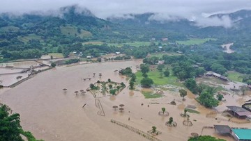
Imagine yourneighborhood flooding for a week. Roads turn into rivers, school is suspended, and food prices climb. That was the reality for thousands of residents in Thailand recently, as the monsoon swell pushed water far beyond the riverbanks and into the streets of low-lying provinces across the Mekong basin. But for most households in these districts, the shock did not come from the water itself. It came from what started moving through the garden, the rice paddy, and the drainage canal.
Reports of snakes of extraordinary length and crocodiles of startling size surfacing in residential areas have turned a hydro-meteorological event into something closer to an ecosystem alarm. And here is the part worth paying attention to: the emergence of large predators is not random cruelty of nature. It is one of the clearest signals that a whole habitat is being displaced, pushed into places humans never planned for.
Why Do Animals Leave Their Home When Water Rises
Think of a crocodile as a landlord with a very specific lease. It claims a stretch of riverbank, a lake, an oxbow pond. That territory is not interchangeable; it holds feeding grounds, nesting sites, and temperature gradients the animal cannot reproduce elsewhere. When current rises several meters and stays there for days, that landlord is effectively evicted, and it moves to the nearest dry, or at least less wet, alternative. That alternative often happens to be a canal behind a housing estate.
Snakes follow the same logic for the same reason. Large constrictors such as reticulated pythons hunt rodents, amphibians, and waterfowl, so when their hunting grounds are drowned, the density of prey concentrates in the remaining patches of dry land. Ibar{FIAT} a factory being flooded and all the workers being forced into the one remaining exit: the animals cluster wherever food and safe footing still exist, and villages sit exactly in those spots.
The scale of the animals adds to the alarm. Asaltwater crocodile (Crocodylus porosus) can exceed four meters in adult length and has been documented reaching well over five meters in parts of Southeast Asia. A full-grown python can surpass five meters too. Neither species is unusually aggressive toward humans; crocodiles generally avoid people unless cornered, threatened, or guarding a nest. The danger is statistical and situational: a frightened, displaced animal in a narrow street has no escape route.
The Technology Behind the Flood Warnings
There is a technology story hiding in this disaster, and it is more useful than the photographs of giant reptiles. Most countries in the region now combine satellite observations with ground sensors to forecast river levels days in advance. One of the workhorses is SAR (Synthetic Aperture Radar, yaitu radar apertura sintetis) mounted on satellites such as Copernicus Sentinel-1. Unlike ordinary optical cameras, radar can see through clouds and rain, mapping flooded surfaces at night and during storms.
On the ground, IoT (Internet of Things, atau internet untuk benda) devices do the last-mile work: water-level gauges, rain gauges, and pressure sensors on bridges transmit readings to a central dashboard. Feeding all of it is AI (Artificial Intelligence, kecerdasan buatan) models that learn how a river behaved the last time it reached a given height, then estimate how the current wave will propagate downstream. Machine learning (pembelajaran mesin) has demonstrated measurable skill at improving short-range flood forecasts when it is given enough historical hydrograph data.
Drone fleets add another layer. Thermal cameras flown over canals can spot basking reptiles and snakes from a safe distance, which lets authorities map a threat zone without anyone walking into it. Ecologists call this bioindicators: species whose movement reveals ecological stress long before a satellite image changes color.
| Metode | Kelebihan | Keterbatasan |
|---|---|---|
| Satelit SAR | Menutup area luas, gagalRegardless cuaca | Resolusi medium, perlu validasi lapangan |
| Sensor IoT | Data real-time, murah, 연속 | Hanya mengukur titik tertentu |
| Drone termal | Presisi tinggi, bisa memetakan satwa | Mahal, tergantung cuaca dan izin |
Air yang naik menghapus batas habitat. Ketika batas itu hilang, satwa liar keluar dari wilayahnya, dan wilayah warga menjadi tempatbaru bagi mereka.
Ke البديلة — say rather: para peneliti liaran yang memantau pergerakan buaya di Thailand routinely emphasize this point: the animals are messengers, not invaders.
What Residents Should Actually Do
Preparedness is the real disruption here. Practical steps matter more than panic: keep a flashlight, a power bank, boots, and dry documents in one waterproof bag; avoid walking through flooded canals at dusk, when crocodiles are most active; and never approach, feed, or corner a displaced animal. Feeding is the single worst option, because it teaches the animal to associate humans with food, which raises encounter risk for everyone.
Authorities should publish combined flood-and-wildlife maps, so evacuation routes do not accidentally run through a python corridor. The deepest innovation, however, is institutional: treating animal sightings as an operational data layer, not as a footnote to a disaster bulletin. When early warning systems, satellite imagery, and field ecology are fused into one ecosystem of information, response time shrinks and lives are protected more efficiently.
Floods will keep coming. Monsoon seasons intensify, urban sprawl eats wetlands, and displacement of large fauna is becoming a recurring feature of extreme weather. The reptiles in the Thai canals are not a horror anecdote; they are a measurement, pointing upstream at a river system under pressure and a warning about what happens when infrastructure, ecosystems, and daily life all compete for the same ground.








Comments (0)